


FEMA has released preliminary updated flood maps for Keene
FEMA Mapping Update Process FAQs
Keene Floodplain Regulations (see Article 24)
Cheshire County Discovery Report
State of NH Floodplain Mapping Activities
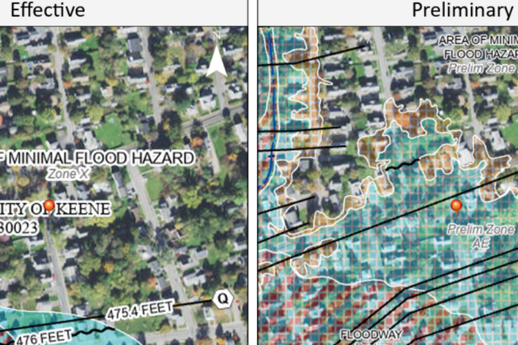
Important: Learn how your property’s FEMA flood map zone and risk are changing.
While these maps are still in the preliminary phase, they will soon become effective, replacing the current FEMA flood maps. The City of Keene participates in the National Flood Insurance Program and uses these maps in our floodplain development regulations.
Use FEMA’s Flood Map Changes Viewer to see what flood zone your property is in on the preliminary maps.
High-risk flood zones start with the letter ‘A’ or ‘V’. Zoom into the FEMA map or enter an address and place a pin to create a map that shows the current 2006 map compared to the 2025 preliminary map for that location. (Read FEMA’s instructions on the map website carefully.)
The maps affect flood insurance requirements in some areas.
Flood insurance is required for a federally-backed mortgage for buildings in high-risk flood zones. Flood insurance is still highly recommended even if you do not have a mortgage or are a renter. Most standard homeowner’s insurance policies do not include coverage for damage due to flooding. Visit floodsmart.gov or contact your insurance agent to learn more.
Read FEMA’s Map Changes and Flood Insurance brochure or contact FEMA’s Mapping & Insurance eXchange helpline at (877) 336-2627 for general mapping or insurance-related questions.
The City of Keene participates in the National Flood Insurance Program (NFIP) and has floodplain development regulations that help to protect lives and property from future flooding. Proposed development in high-risk areas, as shown on the FEMA flood maps, must meet applicable requirements. To learn more, contact Mike Hagan, City of Keene Floodplain Administrator, (603) 352-5440, mhagan@keenenh.gov.
View FEMA’s Mapping Update Process FAQs for detailed information, including:
- Why are the FEMA flood maps being updated?
- What does the updated FEMA maps mean for my community?
- What does the updated FEMA maps mean for residents, businesses, and property owners?
- How are the new maps changing?
- Does my community need to update/amend our floodplain ordinance/regulations?
- When do the new maps need to be adopted into our floodplain regulations?
- When should my community start to utilize the new maps in our floodplain management (permitting, planning, etc.)
- What if I previously received a Letter of Map Amendment (LOMA) for my property?
- What if I believe my property was incorrectly identified as in a Special Flood Hazard Area (SFHA)?
- Who notifies residents of potential changes in their area?
- Will FEMA hold a public hearing or meeting so residents can be made aware of the changes?
- How do I know the status of a mapping project in my community?
- What are the steps involved in updating the flood maps?
- Preliminary maps have been released for my community. Where can I view and download them?
Additional Information
There will be a 90-day appeal period.
The appeal period is expected mid-summer, 2025. The City will share information about when the appeal process begins when that information is received. Public meetings will also occur after the Letter of Final Determination is sent, which will likely be in 2026.
There is an opportunity for property owners to submit technical information regarding map revisions, including appeals.
Formal appeals must be based on data that show the FEMA flood map is scientifically or technically incorrect and generally include engineering information, elevation information, and updated floodplain boundaries. Once the process starts, information about where to send appeals will be shared.
City Contact
Mike Hagan
City of Keene Floodplain Administrator
Community Development Department
(603) 352-5440, mhagan@keenenh.gov